Navigational Risk Alerts
Route types
WNI Navigation displays the following two route types:
Passageplan
Based on the latest passage plan data received by WNI from the vessel, along with weather and the latest AIS position data to determine risk levels
OSR Route
Based on the recommended route according to the client's plan, along with weather and the latest AIS position data to determine risk levels
Regarding OSR Route alerts
Alerts may arise along OSR Routes, which are recommended by WNI based on weather conditions. However, OSR Routes are safe routes in accordance with client requests. Please use OSR Route risk alerts as an extra reference.
Alert types
| Alert type | Explanation |
|---|---|
Offtrack |
The AIS position deviates from the planned route |
Grounding Intersection |
The vessel is expected to enter a Risk Area (Grounding) within 72 hours |
Heavy Rolling |
The vessel is expected to experience higher rolling risk within 72 hours |
NAVAREA Intersection |
The vessel is expected to enter a Risk Area (Navarea) within 72 hours |
Ocean Storm Intersection |
The vessel is expected to enter a Risk Area (Ocean)1 within 72 hours |
Coastal Storm Intersection |
The vessel is expected to enter a Risk Area (Ocean)2 within 72 hours |
UKC Risk (βeta) |
An Offtrack vessel has an increased risk UKC risk (based on vessel Draft) |
NAVTEX Intersection |
The vessel is expected to enter a Risk Area (NAVTEX area) within 72 hours |
Offtrack
Offtrack alerts are calculated based on the distance from latest AIS position to the nearest point on the planned route. If the distance exceeds those in the following table, an alert is displayed.
Offtrack alert thresholds (default settings)
| Middle (Caution) | High (Warning) |
|---|---|
| Distance > 5.0 NM | Distance > 10.0 NM |
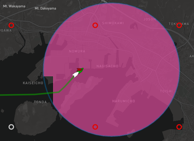
Grounding Intersection
If a route enters an area with a depth of less than 20m within 72 hours, a grounding risk alert is displayed.
Heavy Rolling
A Heavy Rolling risk alert is displayed when Synchronous Rolling / Parametric Rolling risk is expected based on weather, and vessel speed & size.
NAVAREA Intersection
A NAVAREA Intersection alert is displayed when a route intersects with or enters a NAVAREA warning area within 72 hours.
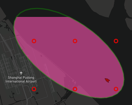
Ocean Storm Intersection
If a route enters a WNI storm area (Ocean) within 72 hours, an Ocean Storm Intersection risk alert is displayed. Storm data is announced daily between 02:00 and 03:00(UTC), and the risk areas are updated at 06:00(UTC).
Coastal Storm Intersection
If a route enters a WNI storm area (Coastal) within 72 hours, an Coastal Storm Intersection risk alert is displayed. Storm data is announced daily between 02:00 and 03:00(UTC), and the risk areas are updated at 06:00(UTC).
UKC Check (βeta)
If a vessel has an offtrack alert of "Middle" or higher, a UKC Check using depth data (0.05 grid) and the vessel's draft is displayed. The area of the UKC Check is based on the vessel's heading (or course, if no heading is available) and speed. If the vessel's draft & depth margin is less than those in the following table, a risk alert is displayed.
NAVTEX Intersection
A NAVTEX Intersection alert is displayed when a route intersects with or enters a NAVTEX warning area within 72 hours.
Note
Vessels that have not received a PassagePlan will not be judged UKC.
| 0knots | 12knots |
|---|---|
 |
 |
UKC Threshold (default settings)
| Middle (Caution) | High (Warning) |
|---|---|
| Draft Margin < 30 % | Draft Margin < 20 % |
Auto layer toggling
Selecting a vessel with any of the following alert types will toggle on the relevant layer.
| Alert type | Toggled layer(s) |
|---|---|
Grounding Intersection |
The grounding layer(s) for which there is an alert |
NAVAREA Intersection |
The NAVAREA layer(s) for which there is an alert |
Ocean Storm Intersection |
The Ocean Storm layer |
Coastal Storm Intersection |
The Coastal Storm layer |